// For a more in-depth view of my research, see either my staff page, Research Gate, GitHub or my recent papers.
// More information on my current major European projects can be found at Hydroscape, GloboLakes and the MARS Project.
// And to see my past European work, go to ForestClim and the Motive Project.
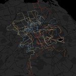
OpenSky: Live Flight Data – Recursive Outputs, Auto-Rendering in R & QGIS
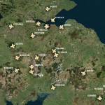
I’m a big fan of Flightradar24 and using it to see planes flying ahead made me wonder, is there an open source way of replicating it? I came across this post by @geodose, which shows
Map of Gaelic Placenames – Version 2!
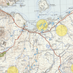
Featuring: AÀA integration, new NLS map layers, community data… After the good reception to the Common Gaelic Placenames Map, I was been thinking about ways to improve it. The first iteration was based on Ordnance
Upgrading the Cartridge on a Sony PS-HX500
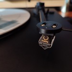
At the start of lockdown, I picked up a Sony PS-HX500 turntable at a decent price. I thought it would be a fun lockdown project to record some of my LPs to digital formats and
Microsoft Flight Simulator (MSFS) 2020: Points of Interest Map
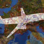
Microsoft Flight Sim (MSFS) 2020 is now out on Xbox Series S|X, allowing more and more people to explore the world by plane. Bringing together a vast amount of aerial imagery, the game can make
Ecurie Ecosse @ Merchiston Mews

During one of my many ‘Wednesday Wanders‘, I found another lovely Mews in Edinburgh. A Mews is a row of stables and carriage houses, but this one’s horsepower was upped somewhat… [link]
Map of Common Gaelic Placenames
Update, 2022: There’s now a version 2 to explore. After posting on twitter about starting to better understand Scottish maps since learning some Gaelic, I was pointed to all sorts of interesting articles, projects, books
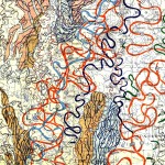
Merging Intersecting Lines in R
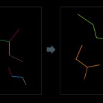
I came across a problem without a clear solution. I had lots (and lots) of line segments, which represented river stretches across GB. All I wanted to do was join together touching segments into a
Playing CHESS with Effective Rainfall (GB)

It’s useful to know how much water enters a system, particularly as part of the runoff model. I’ve always thought of the budget of precipiation (Prec) & potential evapotranspiration (PET) as effective rainfall (Raineff), but
LowPoly Fish: UK Freshwater Species
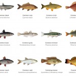
I’ve recently been working on amalgamating as much freshwater fish data as possible, and ended up with a dataset with 350,000+ individual fish records. An amazing dataset, and just a subset – in this case,
Animating Time: QGIS & FFmpeg
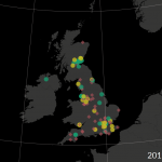
I was recently asked if I could animate this summer’s records from the Bloomin’ Algae App, to help show the spatial patterns as well as the impact of a recent media interest in the subject
RMarkdown Fun!
I recently went to an interesting EdinbR talk on RMarkdown and the workflow available via R Studio and its products. I’d not used any markdown before but had seen its use in documentation, and this
The Seas of the Beaufort Scale
During some recent work with weather data, I was looking at information on the Beaufort Scale and stumbled upon a set of evocative images of the various seas at different points in the scale. There
The Longest Countries Made of Elements
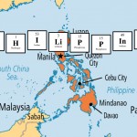
My pub quiz team have started setting a quiz each week to keep us in good form, with one person selecting questions for the others each week. For my last turn (full quiz here, if
UK Wind Data – TIFFs (free)
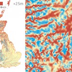
It’s very hard to get decent observed wind data for the UK (and most countries, I imagine), so I was intrigued when I found a 1km resolution database of wind data freely available online. You
Animating Journeys as Maps
Over a few years going on Wednesday Wanders, I’ve collated quite a lot of data on walking routes in and around Edinburgh. In some cases this is time-stamped GPS data taken from the walk, otherwise
RetroPie on a Raspberry Pi 3 = Retro Games!

After the recent release of the Mini NES, I came across an article on building a better system for the same price, with a Raspberry Pi 3 running RetroPie OS. I quite fancied a little
4 Maps of the US Electoral College
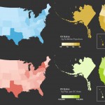
There have been a lot of articles showing up in and around the US election result either calling for the abolition of the electoral college based on its unfair representation of the populous, or the
Blimp-based aerial archaeology, circa 2006
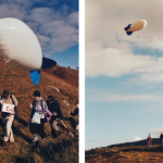
Many years ago now, I was part of a group looking at archaeological GIS and experimenting with the use of a small blimp and remote camera for the purposes of scientific research. These days you
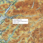
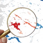
Name That Lake!
Two things coincided this week. The imminent launch of our new UK Lakes Portal illuminated how few lakes we have recorded names for, whilst a visiting work experience student was needing something to do… It
Meander Maps (aka jQuery Slider GIS)
I forget exactly how I first came across this topic, but it’s likely I’d found out there was a town in America called England. When I saw where it was, I panned across the landscape
Seabird Density Visualisation, British Isles
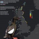
I wanted to do a pretty simple GIS task with some nice visualisation, and in the course of my work had stumbled upon the ‘Magic’ site the government has set up. It’s not the flashiest
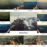
RRS Discovery – Underwater Science!
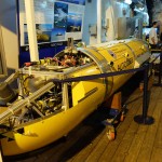
This is roughly halfway between personal research and work, as I won a ballot to get a tour of the RRS Discovery – a NERC research ship that was visiting London for a few days.
Mexican Hexagons! Heat mapping Vienna and more..
Isn’t it amazing how much Mexico looks in no way like north-eastern Austria? But Mexico is hot, and here we’re taking a look at heat mapping.. Having recently seen demos on both hexagonal heat maps and the Qgis2threejs
Doughnuts and Dots: Chartin’ & Graphin’
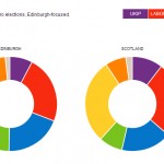
OK, I’m trying to make this topic sound fun.. but there’s only so many ways you can spin online charting libraries.. but if they make delicious donuts and colourful dots, then I might have a