*meiotic*
  • CV
  • InHab50
  • Papers
  • Research
  • Quiz
  • Talks
  • Wanders
  • Whisky

analysis

OpenSky - cover

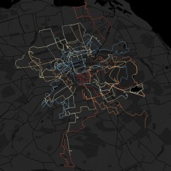
OpenSky: Live Flight Data – Recursive Outputs, Auto-Rendering in R & QGIS

Posted on 8th June 202310th June 2023 by meiotic

I’m a big fan of Flightradar24 and using it to see planes flying ahead made me wonder, is there an open source way of replicating it? I came across this post by @geodose, which shows

Tagged aeroplanes, analysis, maps, opensky, QGIS, R, research Leave a comment
gaelic_map_v2_cover

Map of Gaelic Placenames – Version 2!

Posted on 4th October 20225th October 2022 by meiotic

Featuring: AÀA integration, new NLS map layers, community data… After the good reception to the Common Gaelic Placenames Map, I was been thinking about ways to improve it. The first iteration was based on Ordnance

Tagged analysis, gaelic, GIS, leaflet, maps, OS, research, scotland Leave a comment

Map of Common Gaelic Placenames

Posted on 26th February 202017th August 2023 by meiotic

Update, 2022: There’s now a version 2 to explore. After posting on twitter about starting to better understand Scottish maps since learning some Gaelic, I was pointed to all sorts of interesting articles, projects, books

Tagged analysis, gaelic, GIS, leaflet, maps, OS, research, scotland 7 Comments
mergeLines concept

Merging Intersecting Lines in R

Posted on 13th January 202014th January 2020 by meiotic

I came across a problem without a clear solution. I had lots (and lots) of line segments, which represented river stretches across GB. All I wanted to do was join together touching segments into a

Tagged analysis, CEH, GIS, lines, R, research 2 Comments

Playing CHESS with Effective Rainfall (GB)

Posted on 11th December 201912th December 2019 by meiotic

It’s useful to know how much water enters a system, particularly as part of the runoff model. I’ve always thought of the budget of precipiation (Prec) & potential evapotranspiration (PET) as effective rainfall (Raineff), but

Tagged analysis, CEH, GIS, precipitation, R, research Leave a comment
Countries as Elements - The Philippines

The Longest Countries Made of Elements

Posted on 31st May 20171st June 2017 by meiotic

My pub quiz team have started setting a quiz each week to keep us in good form, with one person selecting questions for the others each week. For my last turn (full quiz here, if

Tagged analysis, chemistry, countries, data, elements, geography, quiz, research Leave a comment
Wednesday Wanders - animated journeys

Animating Journeys as Maps

Posted on 2nd December 20163rd December 2016 by meiotic

Over a few years going on Wednesday Wanders, I’ve collated quite a lot of data on walking routes in and around Edinburgh. In some cases this is time-stamped GPS data taken from the walk, otherwise

Tagged analysis, data, GIS, maps, wanders 4 Comments

4 Maps of the US Electoral College

Posted on 9th November 201611th November 2016 by meiotic

There have been a lot of articles showing up in and around the US election result either calling for the abolition of the electoral college based on its unfair representation of the populous, or the

Tagged analysis, elections, electoral college, maps, research, USA, voting 4 Comments

Blimp-based aerial archaeology, circa 2006

Posted on 23rd April 201623rd April 2017 by meiotic

Many years ago now, I was part of a group looking at archaeological GIS and experimenting with the use of a small blimp and remote camera for the purposes of scientific research. These days you

Tagged analysis, blimp, GIS, research Leave a comment

Seabird Density Visualisation, British Isles

Posted on 21st November 20155th January 2016 by meiotic

I wanted to do a pretty simple GIS task with some nice visualisation, and in the course of my work had stumbled upon the ‘Magic’ site the government has set up. It’s not the flashiest

Tagged analysis, birds, GIS, magic, research, seabird Leave a comment

RRS Discovery – Underwater Science!

Posted on 15th October 20154th March 2016 by meiotic

This is roughly halfway between personal research and work, as I won a ballot to get a tour of the RRS Discovery – a NERC research ship that was visiting London for a few days.

Tagged analysis, nerc, research, rrs discovery, science, underwater Leave a comment


I'm Phil. I live & work in Edinburgh, Scotland. I spend my work time being an Environmental Data Scientist and tweeting about @ScienceAndMaps. I like to cut loose in the Hebrides and am trying to learn the lingo too. I recently passed on the mantle of running the Southside Whisky Club, although I still dabble in the odd whisky expirent with Maltiply and tweet occasionally there too. My research can be further explored on my Research Gate & GitHub, with more visual stuff running on my open source geospatial server, Contours. I carved a spoon and I liked it.